It is an exciting time for Bellingham’s downtown waterfront redevelopment project with the first roads, waterfront park and the adaptive reuse of the historic Granary Building under construction. These amenities will open to the public in 2018 allowing the community to access the downtown waterfront for the first time in over 100 years. This is the most recent step in a process that began with the Port’s purchase of industrial land from Georgia-Pacific. In coordination with the City of Bellingham and Washington State Department of Ecology, the Port committed to clean up the site’s industrial contamination and turn it into something beneficial for all. Following soil and groundwater cleanup efforts, the site was capped, containing pollution and improving storm water drainage. Now the fun part begins – creating a vibrant new waterfront.

Beginning next year, the roads and waterfront park which are under construction will provide quick access from downtown to the water. Over time, new shops, offices, residences and other mixed-uses will be built on the large area of vacant land between downtown and the water. The Port and City are now focusing their attention on ways to enhance public access to and through the interior of the downtown waterfront as these new buildings are developed.
The design team has come up with “Maple Street” and “Waypoint” options, each featuring a slightly different park and road layout. Changing the park and road layout requires the Port to submit a Sub-Area Plan Amendment application to the City of Bellingham by April 1, 2018 to start a review process which is expected to last about one year. Before submitting its application, the Port is inviting the public to comment on the solutions which have been proposed to improve public access to and through the interior of the downtown waterfront. “The Commissioners will take the public input and feedback and make a decision which option to propose to the City,” says Rob Fix, Port of Bellingham Executive Director. “Both the Maple Street and Waypoint options have a strong connection to downtown and a continuous park and trail connection through the site.”
While both versions will retain the same zoning and include a parking garage entrance at Bay Street rather than the large Commercial Street bridge access point in the current approved Sub-Area Plan, there are several key differences:
| Maple Street | Waypoint |
|
|

The public is invited to a series of events beginning with the Commission meeting on December 19 from 12:00 to 4:00 p.m. “We’ll have maps of the area and staff will be there to answer questions, talk about it and explain the differences between the two options. The public can stay and participate in public comment periods for the commission meeting.
This project promises to energize the Bellingham waterfront and remain a local treasure for decades to come. “This community has a strong connection to the waterfront,” says Fix. “We’re glad to listen to what the community finds important and help create a vibrant, mixed-use waterfront. The goal is to restore the health of the land and the water, promote a healthy and dynamic waterfront economy and improve waterfront access.”
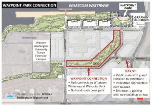
Community members are invited to learn about the two road and park layout options from 12:00 – 4:00 p.m. on Dec. 19 in the Harbor Center conference room (1801 Roeder Avenue). Those who prefer can submit written comments to waterfront@portofbellingham.com.
The Port is planning additional opportunities for community information and input including a January open house. Details will be posted on the Port of Bellingham website as they become available.
Sponsored


