


 (Small)")
516 High Street
Bellingham WA
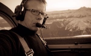
Renowned aerial photographer John Scurlock will give a talk entitled, “Mapping Mountains: Aerial Photography in the Remote Western Ranges of North America,” on February 26, 2020 from 4:00 p.m. to 5:00 p.m. in the Map Collection at Western Washington University Libraries. This event is free and open to the public. During his presentation, Scurlock will talk about the difficulties he has encountered in photographing alpine terrain in regions that have been poorly mapped and seldom visited, with few named features.
John Scurlock has been photographing mountains and glaciers across western North America since 2002. His ground-breaking book, ‘Snow & Spire: Flights to Winter in the North Cascade Range’, was published in November, 2011. He has covered terrain from Alaska to California and from the Coast Mountains and Cascades to the Rockies of Canada and the United States. He has provided images for the Washington State Department of Transportation, the US Geological Survey, Department of the Interior/National Park Service, US Forest Service, Parks Canada, BC Parks, Western Washington University, University of Washington, Simon Fraser University, and the University of Northern British Columbia. This special talk is offered as part of the “Speaking of Maps” program, which are quarterly talks designed to highlight the use and value of maps in research, in teaching and learning, and in daily life. For more information, please contact Dennis Matthews, Map Collection Manager, at Dennis.Matthews@wwu.edu or (360) 650-3272.


