


Winters in Whatcom County can be long, dark, and damp. However, for those with a passion for outdoor recreation—and a closet full of Gortex—this season can still be a time of adventure and exploration. These four hikes are accessible year-round and offer varied options of difficulty, length, and location throughout the county.

Mount Baker area: Horseshoe Bend Trail
- Length: 2.4 miles, roundtrip
- Difficulty: Easy
Making it up to Mount Baker without a set of skis, snowshoes, or a snowboard is tough this time of year. Not only does Mount Baker get some of the highest snowfall in the lower 48 states, it also remains a winter-wonderland far longer than most of the Cascade range.
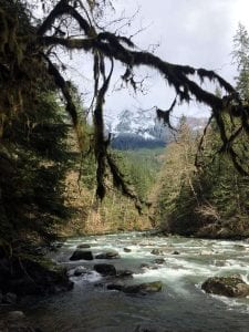
Due to these long snow seasons, it’s important to know where you can catch a glimpse of Mount Baker’s scenery in the winter without all that gear. The Horseshoe Bend trail is an excellent, accessible trail that gets hikers into Mount Baker-Snoqualmie National Forest at a relatively low elevation to avoid snow.
The trail begins just outside of Glacier across the road from the entrance to Douglas Fir Campground. There is plenty of parking at the trailhead on the east side of the road (Highway 542). After parking, follow the stairs down toward the North Fork Nooksack River and grab the trail to the left. The trail hugs the water, bringing visitors across wooden boardwalks and in-view of the impressive river. This trail stays wet, muddy, and sometimes icy throughout the winter and spring, so come prepared. The trail eventually peters out and becomes unclear. Turn around and head back the same way.
Chuckanuts: Oyster Dome Trail
- Length: 6.2 miles, roundtrip
- Difficulty: Difficult
While there’s rarely a bad time to hike Oyster Dome, a crisp, clear winter day can be ideal. During the winter, Oyster Dome doesn’t host the typical summer crowds the trail attracts. Plus, the cool weather can be a comfort on this strenuous trail that climbs 1,900 feet in just over 3 miles.
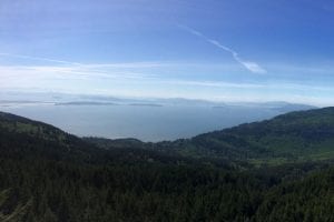
Traveling south from Bellingham, take Chuckanut Drive just past The Oyster Bar restaurant to the west. Park along the road and carefully walk up the road to the trailhead, which is marked with just a small post for the Pacific Northwest Trail. The trail immediately climbs above the road to a formal trailhead sign. Keep climbing. At about a mile in, you’ll reach a bench with a sneak peak of the San Juan Islands.
Remember, these views only get better at the top. Continue for another .5 mile and reach a junction. Follow signs for the Samish Bay Trail to the left. The trail traverses across Blanchard Mountain, crosses a few trickling creeks and comes to a final junction at about 2.8 miles. This time, follow the sign for Oyster Dome to the left. Here, begin the final ascent to the terminus. The trail ends on sheer cliff where the Chuckanut Mountains meet the Salish Sea at 2,000 feet above sea level. Take in the vast views of the San Juan Islands, Olympic Mountains, and Vancouver Island. Soak up the sun (if it’s out!) and enjoy a snack before returning to the dark forest.
In Bellingham: Sehome Arboretum
- Length: More than 6 miles of trails
- Difficulty: Easy-Moderate
The Sehome Arboretum hosts thousands of Western Washington University students annually as a backyard to campus. In addition to students seeking solitude from college-life, the 180-acre property serves as one of Bellingham’s most accessible urban parks.
For residents near downtown, the arboretum can be accessed on foot from Jersey Street. For residents in the Samish Neighborhood, access the arboretum from Allen Avenue or Bill McDonald Parkway. South of Western’s campus, visitors can walk or drive to the entrance on 25th Street, which houses a small parking lot.
For a good walk or run with a destination, follow the Huntoon Trail up to the Lookout Tower (also referred to on some maps as the Communications Tower) and take a quick view of Bellingham before returning.
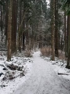
The Huntoon Trail is paved, wide and easy to find within the vast network of trails in the Arboretum. If you decide to explore the rest of the unpaved paths, be sure to come prepared for muddy adventure.
North County: Berthusen Park
- Length: 7 miles of trails
- Difficulty: Easy
Berthusen Park combines history and education with outdoor exploration. The park resides on land once home to Hans Berthusen and his wife Lida Hawley-Berthusen as their family homestead in 1883. When the couple passed away, they generously donated the 236 acres to the City of Lynden as a public park.

Today, visitors can glimpse at local history with a stroll passed the Berthusen Barn or various other out buildings sprinkled across the property. Multiple trails weave their way throughout the property and can be linked together to create a longer loop. For a straightforward walk, take the 1.1-mile Eagle Loop Trail around the park.
The trail was developed by an Eagle Scout troop and provides an accessible route for all experience levels. From the Eagle Loop, visitors can branch off on smaller trails that weave through the park.
These are just a few ideas to get you winter hiking plans percolating. Grab a map, warm gear, boots, and your thickest pair of socks (or two) and get outside!


